|
Wilson's Promontory
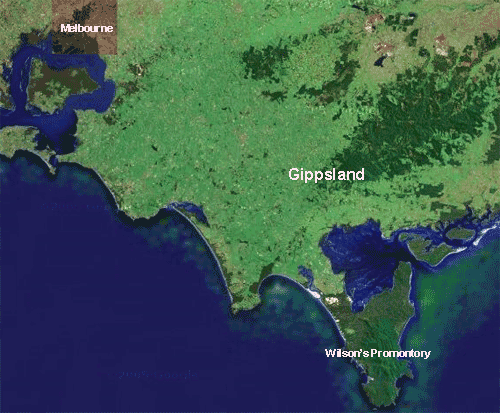
There is a lovely little spot in the region of the state of Victoria known as Gippsland where one can escape from the noise and pressures of everyday life into a world of wildlife and color that is sure to capture your heart. It is renown as the southern most part of the Australian continent and is called Wilson's Promontory.
Here is what walkabout.com.au has to say about the history of the area:
Wilsons Promontory was known as 'Wamoon' or 'Wamoom' by the Aboriginal peoples who collected shellfish there over 6000 years ago. Middens along the western coast testify to their seafood diet. The Dreamtime stories of Lo-An, Bullum-Boukan, and the Port Albert Frog all make mention of the area.
George Bass sited the promontory on January 2, 1798 from a small whaleboat while on an excursion from Port Jackson. Some sources suggest that Bass named the area in honour of his friend - a London merchant named Thomas Wilson. Others indicate that Wilson was a friend of Matthew Flinders. Another story is that Bass originally called it 'Furneaux's Land' and that the name change was made by Governor Hunter. In any case, Bass returned with reports of plentiful supplies and safe anchorage, as well as 9000 seal pelts and several tons of oil. This initiated a sealing rush which only petered out in the 1830s as the number of animals dwindled. Sealers Cove, on the eastern coast, can still be visited today.
Whaling was also practiced from Refuge Cove until that resource also became too scarce for commercial viability in the 1840s. Other industries included quarrying and timber-cutting ceased in the 1850s after another excess of resource destruction, although the mill reopened in the 1880s due to regrowth, which was again depleted by 1906. Tin was discovered near Corner Inlet in the 1870s. However, it was not mined until World War I stimulated demand and it ceased in 1925 with the opening of the Mount Hunter mine.
After visits by naturalists and botanists in 1884, campaigning for governmental protection of the site began competing with cattle interests and settlement plans. As a result The Prom became a national park at the turn of the century. A chalet for tourists and naturalists was built in the 1920s and a training camp for commandos was constructed at Tidal River during the Second World War. The remnants of the latter site were used as the basis for the present visitors' centre. The Yanakie Isthmus, a sandy bar connecting the promontory to the mainland, was added to the park in the 1960s on condition that the seasonal grazing which began in 1852 be allowed to continue. As a result the park now covers 49,000 hectares. It includes thirteen offshore islands and marine reserves around the coast. Cattle enclosures can still be seen near the entrance. Running east to west across the isthmus are two huge sets of dunes known as Big Hummock and The Nobbies which are used as a lookout for the cattle during mustering.(1)
The day after Ari and Dan left us, Fi was to leave us as well. She was invited to spend a week with her girlfriend, Racheal, and her family at the shore town of Lorne. We saw this as an opportunity to do some exploring of a more extended nature. We had been told that the Prom was worth seeing, so we packed an overnight bag and, after dropping Fi off, headed straight down the east side of Port Phillip Bay and then eastward to Wilson's Promontory.
 We were advised to make reservations prior to departure, but that didn't seem to work out as there were entirely too many places to stay and most of them that appeared on the region's tourist website were booked for this weekend, it being high holiday season. We decided to chance finding a smaller place with a clean bed and shower. If we were unsuccessful, we could opt for the two and a half hour drive back home. It was a good gamble. We were advised to make reservations prior to departure, but that didn't seem to work out as there were entirely too many places to stay and most of them that appeared on the region's tourist website were booked for this weekend, it being high holiday season. We decided to chance finding a smaller place with a clean bed and shower. If we were unsuccessful, we could opt for the two and a half hour drive back home. It was a good gamble.
As we approached the park entrance, we spied a "vacancy" sign hanging from one of the local B&Bs. We proceeded to the park check-in, paid for a two-day pass and headed back out the park and snapped up the place for the night. It turned out to be a small cottage overlooking a large field with a large lake in the background and mountains in the distance. Jackpot!
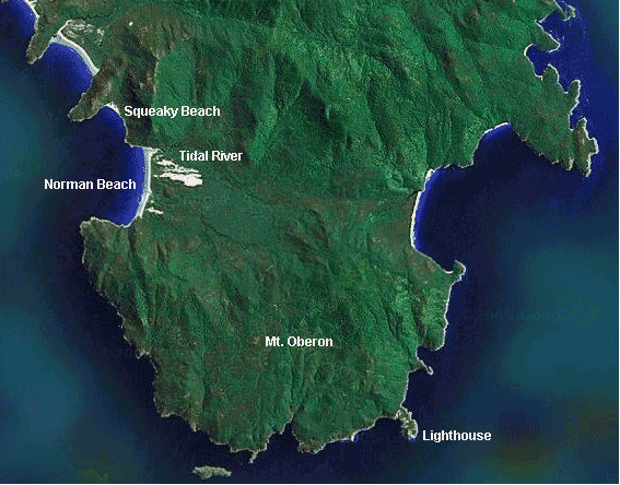
It was back to the park after leaving our overnight things in the cottage. We still had plenty of daylight and we wanted to use it. It was a 30 km drive from the park entrance to the ranger station at Tidal River, the camping zone for the park, over a paved but windy curvey road. This single road was devoid of automobile traffic but not devoid of animal traffic. It was not long before 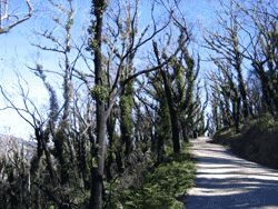 we spied a few kangaroos feeding in a field by the side of the road. We were hoping to see more (and expecting to) so much so that we chose not to stop, but to carry on. We were determined to climb Mt. Oberon before the sun went down. we spied a few kangaroos feeding in a field by the side of the road. We were hoping to see more (and expecting to) so much so that we chose not to stop, but to carry on. We were determined to climb Mt. Oberon before the sun went down.
Tidal River is a glorified campground. At the site of the ranger station, all persons wanting to hike the park overnight needed to register with this office. It was a combination permit center and museum, complete with displays and literature for a range of interests from those day hiking to a more encapsulating experience. Surrounding the ranger station were campsites that were completely full. Next to the station was a grocery store and movie theatre. This was a vacation center. (We were told that one must book at least a year in advance to be guaranteed a site.) The place was teaming with family activity. We drove the length of the short access road to get a feel for the size of the place. While not large, it seemed that all were quite happy with the accommodations.
After determining where we needed to g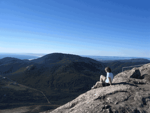 o to gain access to the mountain, we drove to the car park about half way up and began our ascent. It was an easy climb through the forest on a dirt access road. Along the way, there was evidence of a previous forest fire (bush fire) and more interestingly, evidence of the re-emergence of the forest. Lots of green shoots were growing out of the charred and blackened trees, some of which had fallen while others remained standing. o to gain access to the mountain, we drove to the car park about half way up and began our ascent. It was an easy climb through the forest on a dirt access road. Along the way, there was evidence of a previous forest fire (bush fire) and more interestingly, evidence of the re-emergence of the forest. Lots of green shoots were growing out of the charred and blackened trees, some of which had fallen while others remained standing.
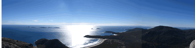
Twenty minutes later we came upon the base of the communications tower that was planted just below the summit of the mountain. From here it would require the scaling of steps placed on the rocks and cut into the rocks till we gained the top. The vista we beheld can be seen at the top of this page. We spent the next half hour drinking in the view. It was quite evident from above that the fire damage done to the park was extensive. We later learned that this was due 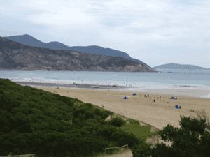 to a deliberate "burn-back" by officials to regenerate the forest. Unfortunately, the officials who managed the burn neglected to inform the public. Unprepared for what ensued, some folks had to be helicoptered out of the forest when the burn got out of control. It seems the same officials did not check the weather forecast. When winds whipped up, it spread the fire so rapidly that it was uncontrollable. In some places the fire jumped one kilometer before re-igniting. The lighthouse at the end of the park was almost destroyed. to a deliberate "burn-back" by officials to regenerate the forest. Unfortunately, the officials who managed the burn neglected to inform the public. Unprepared for what ensued, some folks had to be helicoptered out of the forest when the burn got out of control. It seems the same officials did not check the weather forecast. When winds whipped up, it spread the fire so rapidly that it was uncontrollable. In some places the fire jumped one kilometer before re-igniting. The lighthouse at the end of the park was almost destroyed.
Reluctantly, we headed back down the mountain. At the car, we paused to read some of the literature posted at a kiosk by the lot and then headed back to Tidal River. Just outside of the town, stood a lonely state police car ... doing sobriety checks. For the first time EVER I had to blow into a tube attached to a hand-held 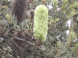 device. Of course, it registered 0.00, but I was pretty excited to see these units in action. The officer gave me the tube as a souvenir. I wanted to pepper him with questions, but he didn't look like he wanted to invite any, so I just continued on to the camp. We drove to the end where we had seen a parking lot earlier, got out and walked to Norman beach to check it out. device. Of course, it registered 0.00, but I was pretty excited to see these units in action. The officer gave me the tube as a souvenir. I wanted to pepper him with questions, but he didn't look like he wanted to invite any, so I just continued on to the camp. We drove to the end where we had seen a parking lot earlier, got out and walked to Norman beach to check it out.
This beach afforded us a beautiful view of where we had been and more. There was a broad open sandy beach area that extended for almost a kilometer. The tide seemed to be out and people were surfing, sitting on the sand, walking or fishing. We walked around some more and then headed back to the car to decide about dinner. We tried to get something at the grocery store, but it had closed for the night, so we just drove back to the cottage and used what we brought with us to fix some dinner. The nearest eating establishment was 50 km away in Fish Creek. By the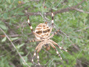 time we got there, most places would probably be closed. time we got there, most places would probably be closed.
That night it rained and the wind blew hard enough to rattle the wood stove damper that had been installed in one corner of the front room. We watched a bit of news on the "tele" as they call it here, and then read till about ten pm. We both retired after a good afternoon's hiking and slept quite well.
The next morning the weather was rainy. We had paid for "brekky" (another example of the local lingo) so we decided to eat it slowly in the hopes that the weather would improve. Seeing that the rain was not going to abate quickly, we packed up our things and headed back to the park for another day of hiking.
We chose a trail that was "under cover of 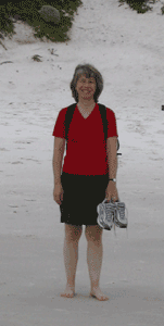 forest" so as to remain as dry as possible. It was a relatively flat trail with plenty of flora for us to explore. One of the more popular plants was called a Banksia (see the photo). We also managed to recognize a gum tree that was oozing thick red sap. Completion of this trail brought us back to the ranger station and the beach area. We paused for lunch which we bought at the grocery store and then proceeded to cross the Tidal River via a bridge provided by the park and walk up and over the ridge that separated Norman beach from Squeaky beach. Along the way we discovered the largest spider we have seen in Oz. The beach itself derives its name from the noise it makes when you walk through it. It actually does squeak. forest" so as to remain as dry as possible. It was a relatively flat trail with plenty of flora for us to explore. One of the more popular plants was called a Banksia (see the photo). We also managed to recognize a gum tree that was oozing thick red sap. Completion of this trail brought us back to the ranger station and the beach area. We paused for lunch which we bought at the grocery store and then proceeded to cross the Tidal River via a bridge provided by the park and walk up and over the ridge that separated Norman beach from Squeaky beach. Along the way we discovered the largest spider we have seen in Oz. The beach itself derives its name from the noise it makes when you walk through it. It actually does squeak.
After walking around on the road and over the back end of the ridge to get back to the bridge, we were both tired and ready to head home. The drive back was uneventful and we ended this adventure with a pleasant memory of the park and the knowledge that we would be going back there again before we leave to enjoy more of the park. A trip to the lighthouse is our next hike.
|
|